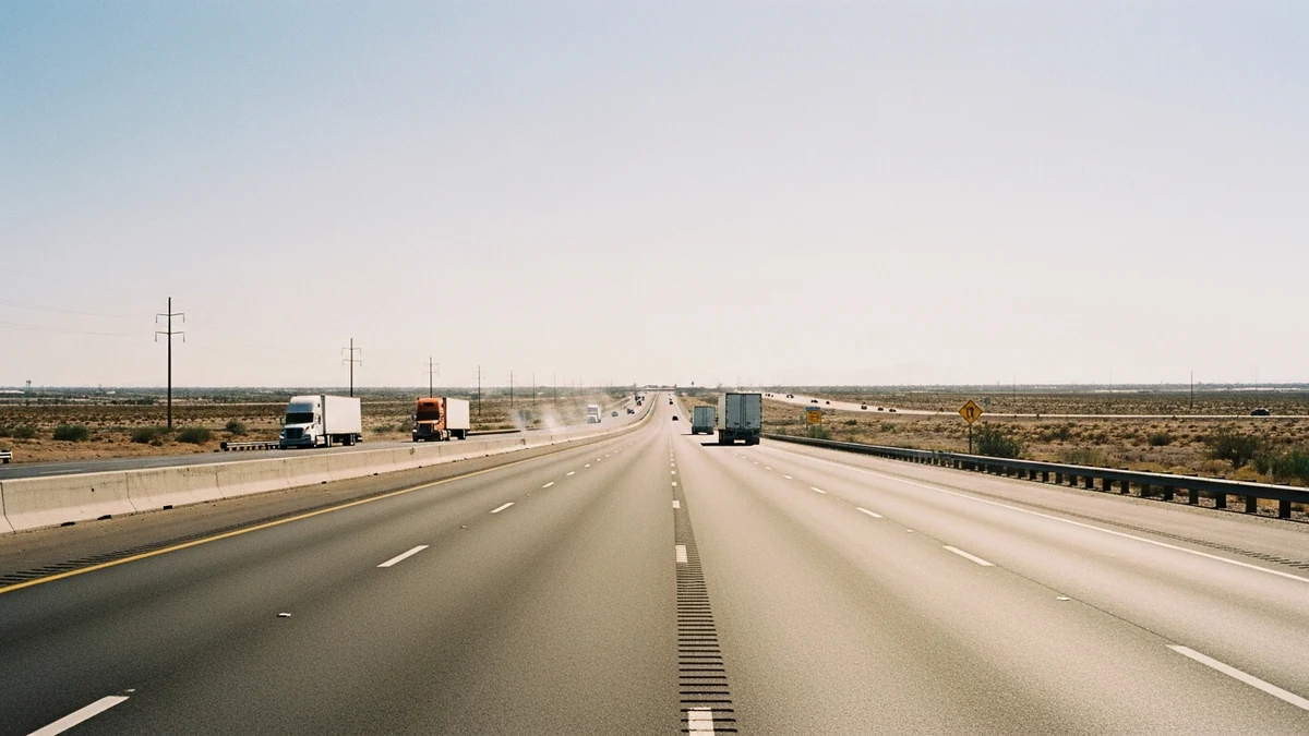
The I-10 corridor through Buckeye and Goodyear is one of the deadliest stretches of highway in the West Valley. You can feel it when you drive it. The speed, the trucks, the way traffic bunches near the MC 85 interchange, the long unbarriered median stretches where a wrong-way driver has nothing to stop them until they hit you.
ADOT’s 2024 Crash Facts report, published July 9, 2025, documents the scope of the problem across Maricopa County and gives us the best public window into what this corridor produces every year.
The Highway That Connects Us Also Kills Us
The I-10 corridor runs through some of the fastest-growing communities in Arizona. The Papago Freeway segment carries somewhere between 80,000 and 130,000 vehicles per day depending on the segment, according to ADOT traffic count stations.
That volume alone would make it dangerous. But I-10 through Buckeye and Goodyear has specific problems that other stretches don’t.
The speed limit is 65 mph inside Goodyear and jumps to 75 mph west of Estrella Parkway. Trucks run at 65 across both zones. That speed differential creates compression points where passenger vehicles stack up behind semis and then try to pass in tight windows.
There’s no median barrier on long stretches west of SR-85. Cross-median crashes are among the most lethal crash type on any highway. Statewide in 2024, ADOT recorded 771 people killed in lane departure crashes, which includes cross-median events. That figure is from Table 1 of the 2024 Crash Facts.
The Numbers ADOT Publishes (And What They Mean)
ADOT’s annual Crash Facts report tracks every reportable crash statewide. A crash is reportable if it involves a fatality, an injury, or property damage above $2,000. Police agencies submit crash reports; ADOT codes them and publishes annual summaries. The 2024 report covers calendar year 2024 and was published July 9, 2025.
Here’s what the 2024 data shows for Maricopa County.
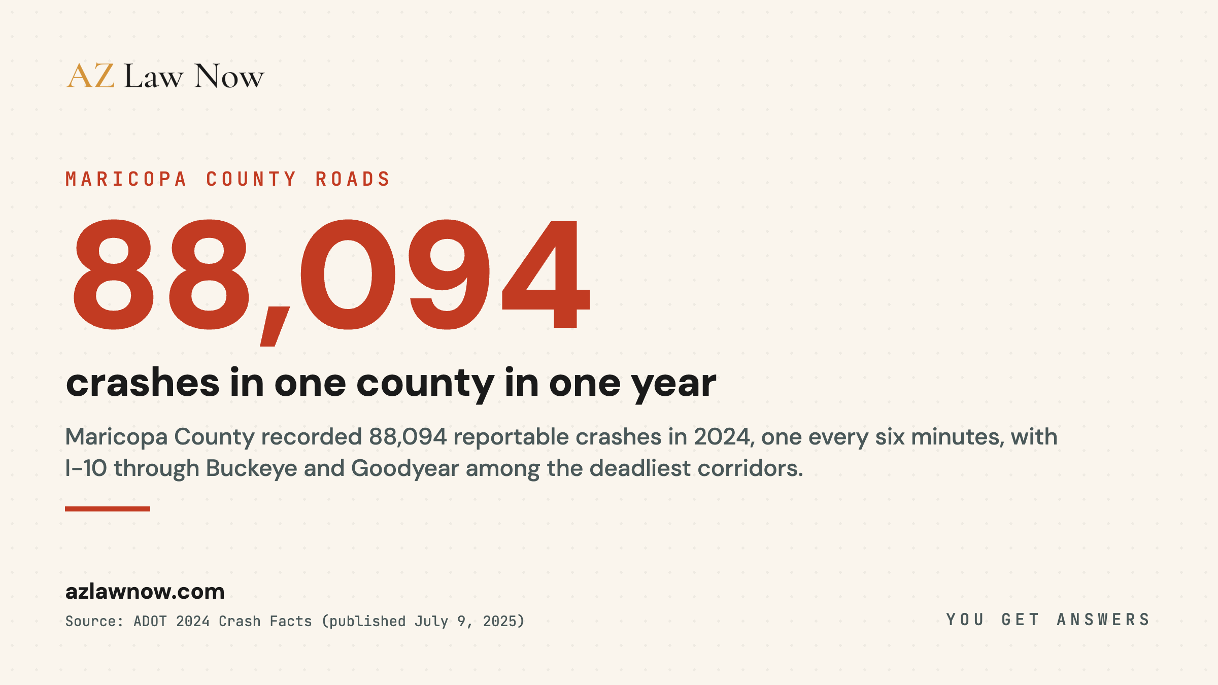
2024 Maricopa County Data
88,094
total reportable crashes. That’s 241 per day. One every six minutes.
594
persons killed. Down from 682 in 2023 and from the 2022 peak. Three consecutive years of elevated fatalities have been followed by two years of decline, but 594 deaths in a single county in a single year isn’t a trend line to feel comfortable about.
25,990
injury crashes. That’s crashes where at least one person was transported or treated at the scene.
For city-level data: Buckeye recorded 970 total reportable crashes and 7 persons killed in 2024. Goodyear recorded 1,869 total reportable crashes and 14 persons killed. These are city-wide totals across all roads within city limits, per ADOT’s jurisdiction-level breakdown in Table 2-5 of the 2024 Crash Facts.
Statewide in 2024, ADOT recorded 417 persons killed in speed-related crashes, where the investigating officer marked “speed too fast for conditions” or “exceeded lawful speed” as a contributing factor. At 75 mph, the energy in a collision is more than double the equivalent at 55 mph. Physics doesn’t negotiate.
Hazen Road and SR-85: The Intersection That Should Have Been Fixed
If you drive west on I-10 past Goodyear, SR-85 is the major interchange. It connects I-10 to I-8, runs south through Gila Bend, and handles a significant share of truck traffic moving between Phoenix and Yuma.
The interchange itself isn’t the worst problem. It’s the surface streets feeding into it.
Hazen Road crosses SR-85 about a quarter mile south of the I-10 ramps. It’s a two-lane road that serves residential neighborhoods on the east side and agricultural land on the west. The intersection has a traffic signal, but the geometry is wrong.
Drivers coming off SR-85 at highway speed hit a light they don’t expect. Drivers on Hazen Road entering the intersection face traffic coming from three directions at three different speeds.
Between 2020 and 2024, ADOT’s crash database shows five fatal collisions at or within 500 feet of the Hazen Road and SR-85 intersection. Seven people died.
Two of those crashes involved left-turning vehicles struck by through traffic on SR-85. One involved a pedestrian crossing Hazen Road at night with no crosswalk and no street lighting. One was a T-bone collision where a driver ran the red signal. One was a semi that failed to stop and pushed a sedan into the intersection.
MAG has flagged the SR-85 corridor at Hazen Road in safety studies for above-average crash frequency relative to traffic volume. The intersection handles far less daily traffic than most high-crash intersections elsewhere in the Valley, which makes its fatality record more notable when normalized for volume.
ADOT approved a safety study for the SR-85 corridor in 2023. The study recommended geometric improvements at Hazen Road. As of April 2026, construction hasn’t started.
Broadway Road and SR-85
Three miles south of Hazen Road, Broadway Road crosses SR-85 with a similar setup. Traffic signal. Mixed-speed traffic. Agricultural trucks turning onto a state highway where passenger vehicles are doing 55 to 60 mph.
The pattern here parallels Hazen Road. Between 2020 and 2024, ADOT data shows 23 reportable crashes at Broadway and SR-85. Three involved serious injuries. One was fatal.
The fatal crash happened in November 2023. A driver heading east on Broadway Road pulled into the SR-85 intersection on a green arrow. A northbound truck on SR-85 ran its red light at approximately 55 mph and struck the driver’s door. The driver was pronounced dead at the scene.
What makes Broadway and SR-85 worth flagging isn’t just the crash data. It’s the growth pattern. Buckeye’s southern expansion is pushing residential development closer to these intersections every year.
Five years ago, Broadway Road west of SR-85 was mostly farmland. Now there are housing subdivisions within a quarter mile. More homes mean more daily trips through an intersection that was designed for agricultural traffic volumes. The signal timing, lane configuration, and sight lines haven’t changed. The traffic has.
Why Buckeye’s Growth Makes This Worse
Buckeye has been among the fastest-growing cities in the United States by percentage over the past several years, according to Census Bureau estimates. The city added tens of thousands of residents between 2020 and 2024, with its population now exceeding 100,000.
The Teravalis master-planned community is approved for up to 100,000 residents at full buildout per developer plans. Howard Hughes Holdings has infrastructure permits and signed water agreements. When Teravalis reaches even a fraction of planned capacity, the resulting daily vehicle trips will overwhelmingly touch I-10.
ADOT’s I-10 widening project between Loop 303 and Verrado Way added lanes in 2022 and 2023. That helped in those segments. But the widening stops at Verrado Way. West of that point, I-10 narrows back to four lanes (two each direction) through some of the fastest-growing residential areas in the state.
ADOT has active or planned construction projects on I-10 between Sarival Avenue and the SR-85 interchange through 2028. Construction zones on high-speed highways are documented elevated-risk environments. Rear-end crashes are the most common crash type statewide, representing 37.51% of all multi-unit crashes per ADOT’s 2024 Crash Facts, and construction zones concentrate exactly the stop-and-go conditions that produce them.
The math isn’t complicated. More residents, more vehicles, same road capacity west of Verrado Way, active construction, and speed limits that top out at 75 mph. The crash numbers will keep climbing unless infrastructure catches up.
Goodyear faces a similar but less acute version of the same problem. The city’s population grew from roughly 95,000 in 2020 to over 115,000 in 2024. The I-10 and Bullard Avenue interchange, the I-10 and Litchfield Road interchange, and the I-10 and Dysart Road interchange all show increasing crash frequency year over year in ADOT’s data.
What the Data Doesn’t Tell You
ADOT’s Crash Facts report is the best public dataset available. It’s also incomplete in ways that matter.
First, it only counts reportable crashes. Fender benders under $2,000 in damage with no injuries don’t make the dataset. Industry estimates suggest the actual number of collisions is two to three times higher than the reportable count.
Second, the data lags. The 2024 report published in July 2025 uses data submitted by police agencies throughout 2024. Some agencies take weeks or months to submit reports. The Buckeye Police Department and Maricopa County Sheriff’s Office both feed into the system, but on different timelines. ADOT acknowledges the dataset is a snapshot, not a complete record.
Third, severity coding is inconsistent. A crash coded as “possible injury” might involve someone who went to the ER the next day with neck pain that turned into months of treatment. The initial severity code never gets updated. The data systematically undercounts serious injuries.
Fourth, the data doesn’t capture long-term outcomes. A “non-fatal injury” crash might involve a traumatic brain injury that changes someone’s life permanently. A spinal cord injury. A shattered pelvis requiring two surgeries and a year of rehab. The crash report records what happened at the scene. It doesn’t record what happened in the months and years after.
Fifth, ADOT’s published summaries don’t break down fault in a way that’s publicly accessible. The crash reports themselves contain fault determinations, but the published Crash Facts aggregate everything. You can’t easily see, from the public data, how many I-10 crashes were caused by speeding versus distracted driving versus impairment versus mechanical failure.
The Arizona Crash Information System allows more granular queries for registered users, but access requires a registered account and the interface isn’t designed for public use. It’s the only way to pull intersection-level data without filing public records requests.
Sixth, commercial vehicle data in the state system doesn’t always align with federal records. A semi involved in a fatal crash shows up in ADOT’s data. But the contributing factors, the carrier’s safety record, the hours-of-service violations that might have caused the crash, none of that shows up in the state database. You have to pull FMCSA records separately.
What You Can Do If You Crash on I-10
If you’re in a crash on I-10 in Buckeye or Goodyear, the first 48 hours matter more than most people realize.
Get medical attention, even if you feel fine. Adrenaline masks pain. Soft tissue injuries, herniated discs, and concussions don’t always show symptoms at the scene. An ER visit or urgent care visit within 24 hours creates a medical record that connects your injuries to the crash.
Without that record, insurance companies will argue the injuries happened somewhere else. Adjusters deny claims specifically because the person waited several days to see a doctor.
Don’t give a recorded statement to the other driver’s insurance company. They’ll call fast, sometimes within hours. They’re not calling to help you. They’re calling to get you on record saying something they can use to reduce your claim.
Document everything. Photos of the vehicles from every angle. The road surface. Traffic signals. Weather conditions. Skid marks. Debris. Photos of your injuries the day of the crash and every day for a week after.
Screenshots of the location on your phone’s map. Get the other driver’s insurance information, their license plate, and the responding officer’s name and badge number.
If the crash happened in a construction zone, document the construction signage, lane markings, barriers, and any workers or equipment visible. The construction company may bear partial liability if signage was inadequate or lane transitions were unsafe.
Call a lawyer before you call your own insurance company. Arizona follows pure comparative negligence under ARS 12-2505. That means your compensation gets reduced by your percentage of fault. Insurance adjusters on both sides are trained to shift fault onto you. A lawyer who handles I-10 crashes in the West Valley knows the common patterns, the intersection-specific issues, and the ADOT data that supports your case.
Our team handles I-10 crash cases in Buckeye and Goodyear. We know these intersections. We work with ADOT published data and crash reports for every case we take. Call (602) 654-0202 or use the contact form. The intake is confidential. We don’t charge unless we recover money for you.
If a loved one was killed in a crash on I-10, Arizona’s wrongful death statute (ARS 12-611) gives the surviving spouse, children, or parents the right to file a claim. The statute of limitations is two years from the date of death, not the date of the crash.
But evidence disappears fast. Skid marks fade in weeks. Surveillance footage from nearby businesses gets overwritten on 30-day loops. Witness memories change. The responding officer’s notes are detailed at the time and vague six months later. Starting early matters more than most families realize.
If the crash involved a commercial truck, the stakes are higher and the timeline is tighter. Trucking companies have rapid-response teams that arrive at crash scenes within hours. They’re preserving evidence for their side.
The driver’s electronic logging device data, the truck’s black box, the carrier’s maintenance records, these can all be destroyed or overwritten if nobody requests preservation quickly enough. An attorney who handles trucking crashes on I-10 knows to send a spoliation letter the same day.
What Happens Next
This article will be updated as ADOT publishes new data. The 2025 crash data should be available in mid-2026. Based on the growth trajectory and construction timeline, the corridor risk is unlikely to improve without infrastructure investment that matches the pace of residential development west of Verrado Way.
The Buckeye City Council and Maricopa County Board of Supervisors both have transportation safety on their agendas. Whether that translates to actual infrastructure investment on the I-10 corridor remains to be seen. ADOT controls the interstate and the state highways. Local governments control the surface streets that feed into them. That jurisdictional split means nobody owns the whole problem.
If you have information about a crash on I-10 that you think we should cover, reach out.
Related Coverage
For the legal and process context, see Ron DeBrigida’s guide to Arizona car crash law, Stephanie Ramirez’s car crash first 48 hours, the car crashes practice overview.
Motorcycle riders face a compounded version of the corridor risk documented here. Buckeye’s SR-85 and I-10 mix is the same high-speed, high-truck-volume environment, but without vehicle structure absorbing impact energy. If you were hurt on a motorcycle in Buckeye, the Buckeye motorcycle accident lawyer page covers the intersection-specific factors, Arizona’s helmet and fault statutes, and what we investigate on West Valley motorcycle cases.
For families and drivers hurt on this corridor by city: Buckeye car accident lawyer, Buckeye wrongful death lawyer, Goodyear car accident lawyer, Goodyear motorcycle accident lawyer.
Frequently asked questions
How many crashes happen on I-10 in Buckeye and Goodyear each year?
What's the most dangerous intersection near I-10 in the West Valley?
Why is the fatality rate on I-10 through Buckeye elevated compared to urban corridors?
Where can I find ADOT crash data for my specific crash location?
Will the I-10 widening project reduce crashes?
What should I do if I'm in a crash on I-10?
Is AZ an at-fault state for car accidents?
Can a car accident cause spinal stenosis?
Who pays when you are hit by an uninsured driver?
What is the three-collision rule?
Sources & references
- Arizona Department of Transportation. (2025). 2024 Arizona Motor Vehicle Crash Facts. Published July 9, 2025. Retrieved from https://azdot.gov/sites/default/files/2025-07/2024-Crash-Facts.pdf
- Arizona Department of Transportation. (2025). Arizona Motor Vehicle Crash Facts. Retrieved from https://azdot.gov/planning/traffic-safety/arizona-motor-vehicle-crash-facts
- Arizona Department of Transportation. (2025). Crash Data Hub. Retrieved from https://azdot.gov/tags/crash-data
- Arizona Department of Public Safety. (2025). Highway Patrol. Retrieved from https://www.azdps.gov/hp
- Arizona Department of Transportation. (2025). Arizona Crash Information System (ACIS) https://azdot.gov/business/transportation-systems-management-and-operations/operational-traffic-safety/arizona-crash-0
- Maricopa Association of Governments. (2023). Top 100 Crash Intersections Report https://azmag.gov/Programs/Transportation/Safety-Program/Top-100-Crash-Intersections
- Arizona Department of Transportation. I-10 Widening, SR-85 to Citrus Road https://azdot.gov/projects/central-district-projects/i-10-widening-sr-85-to-citrus-road
- US Census Bureau. (2024). Buckeye City, Arizona QuickFacts https://www.census.gov/quickfacts/fact/table/buckeyecityarizona