Update, July 11, 2026: New analysis of 25 years of federal crash data finds Arizona’s single deadliest patch for pedestrians sits on this same corridor, east of 39th Avenue, where the ReVISIONing project ends: 53 people killed walking since 2000, between roughly 27th and 35th avenues.
Update, July 2, 2026: Arizona launched Arrive Alive Arizona, a five-year statewide traffic safety campaign, on June 29. Our new investigation puts it against the state’s own 25-year fatality record and its written 20%-by-2030 target.
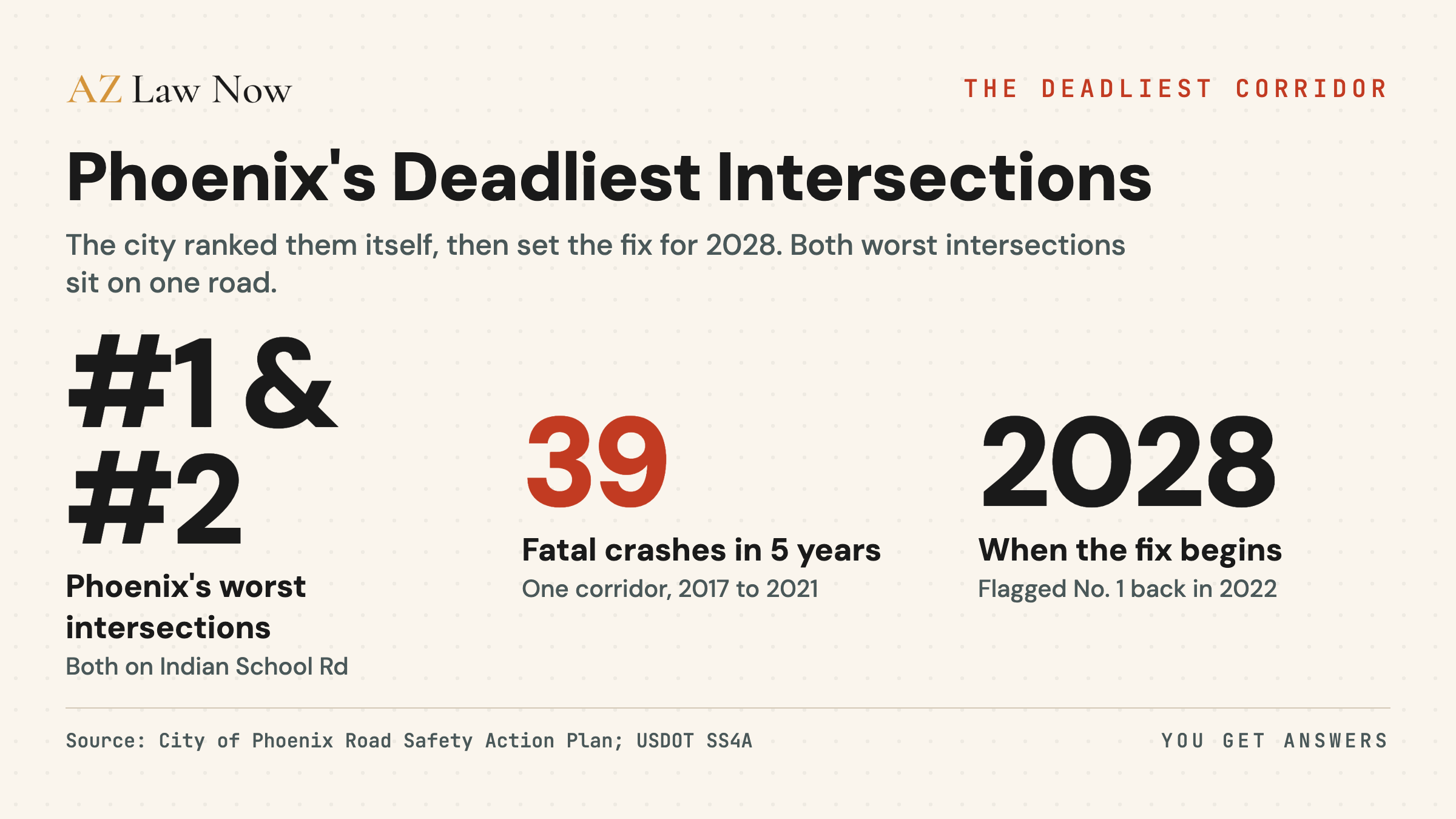
Phoenix already ranked its own deadliest intersections. It did it in a document the City Council adopted on September 7, 2022. The single highest-crash-risk intersection in the city is 75th Avenue and Indian School Road. The second is 67th Avenue and Indian School Road. Both sit on the same arterial, less than a mile and a half apart, on a stretch where the City’s federal grant paperwork counts 39 fatal crashes in five years.
I don’t have to argue that Indian School Road is dangerous. The City of Phoenix already made that finding, in writing, and put a number on it.
The City Ranked These Roads Itself
The Phoenix Road Safety Action Plan is the city’s Vision Zero document. The City Council adopted it on September 7, 2022. It builds what the plan calls a High Injury Network, a data-ranked list of the intersections and corridors where people are most likely to be killed or seriously hurt, drawn from regional crash data.
The plan’s own ranking says it plainly: the intersections with the greatest crash risk are, in order, 75th Avenue and Indian School Road first, then 67th Avenue and Indian School Road second, then 67th Avenue and McDowell Road third. Five of the city’s 20 most dangerous intersections sit on Indian School Road. No other road in Phoenix carries five of the top 20, and the two worst intersections in the entire city are both on this one corridor.
For context on how Phoenix got here, the same plan opens with the city’s own daily arithmetic, drawn from 2015 through 2019 data: 83 crashes a day, one fatal crash every other day, about 190 people killed a year. I cover that statewide design pattern separately in Arizona Pedestrian Deaths: 2x National Average and in the West Valley dangerous intersections report. This piece is about one corridor the City singled out, and what happened next.
Thirty-Nine Deaths, Five Years, One Corridor
When the City applied for federal money to fix Indian School Road, it had to document the problem. Its Safe Streets and Roads for All grant materials state that the corridor between 91st and 39th avenues recorded 39 fatal crashes and 85 serious-injury crashes between 2017 and 2021. The City reports that 48 percent of those crashes involved a person walking or biking.
That is the City’s number, in the City’s grant paperwork, describing a five-year window that ended in 2021. The plan that ranked this corridor was adopted in September 2022. So by the time Phoenix formally named Indian School Road one of its deadliest roads, the bodies were already counted and the count was already public.
What I don’t have yet is the count for the years since. The grant data stops at 2021. The Road Safety Action Plan was adopted in 2022. The federal money landed in December 2023. The construction doesn’t start until 2028. The crashes in that gap are the part of this story the public portals don’t show, so I asked for them.
The Money Came in 2023. The Construction Comes in 2028.
In December 2023, the U.S. Department of Transportation awarded the City of Phoenix $24.96 million through its Safe Streets and Roads for All program for the project the City calls ReVISIONing Indian School Road. The grant program was created by the Infrastructure Investment and Jobs Act. The award covers the same 91st-to-39th-avenue corridor.
The fix is real and specific. The City’s project page lists improved corridor lighting, raised medians, pedestrian crossing signals, modernized traffic signals, and sidewalks separated from traffic. These are the standard countermeasures for exactly the crash types the City documented: people walking, in the dark, across a wide arterial.
Here is the timeline, every date from a City or federal primary source:
Roughly six years separate the City’s formal identification of Indian School Road as one of its deadliest corridors from the anticipated start of construction. The federal money has been in hand since December 2023.
The City is hosting a community conversation about this corridor and four other West Phoenix transportation projects on Thursday, May 21, 2026, at the Neighborhood Services Department office on West Flower Street. The Indian School Road corridor runs through Maryvale, in the same council district whose vice mayor signed the 2022 Road Safety Action Plan. Residents going to that meeting are entitled to ask a direct question: the City ranked these intersections first and second in 2022 and has held the construction money since 2023, so what has happened on the road in the years the design has taken.
What I Asked the City
The grant data ends in 2021. To measure what the corridor has done since the City named it and since the money arrived, I’m filing a public records request with the City of Phoenix Street Transportation Department under ARS 39-121. The request asks for crash records on Indian School Road between 91st and 39th avenues for calendar years 2021 through 2025, including fatal and serious-injury counts by year and by intersection, and any interim safety measures installed on the corridor since the 2022 plan.
Under ARS 39-121.01, a public body must respond promptly, and Arizona agencies commonly treat ten business days as the working window for records of this kind. The City had not responded as of publication. I’ll update this report with what the City provides, what it withholds, and the stated reason for any denial. If the City installed interim improvements on this corridor before 2028, that belongs in this record too, and the request asks for it.
What the Data Means
This isn’t a story about a missing study. The study exists. The City wrote it, ranked Indian School Road first and second in the entire city, adopted it by council vote in September 2022, used those numbers to win nearly $25 million in federal money in December 2023, and then set a construction start of 2028. The accountability question isn’t whether Phoenix knows this road is dangerous. The City’s own documents prove it has known, with precision, for years. The question is what a six-year distance between a city ranking its deadliest intersection and breaking ground to fix it means for the people who use that intersection in the years between, on a corridor where the City’s own paperwork already counts the dead in the dozens. The 2017-to-2021 number is public. The number since is what I’ve now asked the City to produce.
Just over half the crashes on this corridor involved vehicles rather than someone on foot or a bike. If you were hurt in a car crash in Phoenix, our guide for a Phoenix car crash lawyer covers the Arizona statutes that apply and what we investigate, including a corridor’s documented crash history.
Readers trying to understand the legal framework around a pedestrian crash can read Ron DeBrigida’s guide to Arizona pedestrian laws under ARS 28-790 to 28-797. Anyone dealing with the immediate aftermath of a crash on foot can read Stephanie Ramirez’s pedestrian crash action plan and the firm’s pedestrian crash practice overview.
Frequently asked questions
What are the most dangerous intersections in Phoenix?
How many people have died on Indian School Road in Phoenix?
What is the ReVISIONing Indian School Road project?
When will Indian School Road be fixed?
Who is liable if I'm hit by a car on Indian School Road?
Does a city's own safety study matter in a crash case?
Sources & references
- City of Phoenix Street Transportation Department. (2022). Road Safety Action Plan (Vision Zero), adopted September 7, 2022. Retrieved May 18, 2026, from https://www.phoenix.gov/content/dam/phoenix/streetssite/documents/vision_zero_road_safety_action_plan.pdf
- City of Phoenix. (n.d.). Indian School Road Safety Corridor from 91st Ave to 39th Ave (ReVISIONing Indian School Road). Retrieved May 18, 2026, from https://www.phoenix.gov/streets/isr91-39ave
- City of Phoenix Street Transportation Department. (n.d.). Road Safety Action Plan / Vision Zero. Retrieved May 18, 2026, from https://www.phoenix.gov/streets/roadsafety
- U.S. Department of Transportation. (2023). Safe Streets and Roads for All (SS4A) Grant Program, FY2023 Implementation Grant awards. Retrieved May 18, 2026, from https://www.transportation.gov/grants/SS4A
- AZBEX. (2024, January 2). USDoT Awards Phoenix $25M for Indian School Changes. Retrieved May 18, 2026, from https://azbex.com/planning-development/usdot-awards-phoenix-25m-for-indian-school-changes/
- Arizona Revised Statutes 39-121 and 39-121.01 (Public Records). Retrieved May 18, 2026, from https://www.azleg.gov/ars/39/00121.htm